Reality Capture by True North Positioning
In today's fast-paced world, accurate and reliable spatial data is crucial for informed decision-making. Our Reality Capture solutions, offers unparalleled precision and efficiency for your mapping and surveying needs.
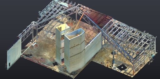
Our advanced Reality Capture technology, ensures that every project is executed with the highest level of accuracy. This alignment guarantees that all spatial data is geo-referenced correctly, providing you with reliable and precise point clouds and models. Whether you need detailed 2D drawings, 3D models, or digital surface models (DSMs), our solutions are designed to meet your specific needs and exceed your expectations.
At True North, we understand the diverse requirements of various industries, from urban planning and environmental monitoring to infrastructure management. Our versatile and efficient Reality Capture services streamline your workflow, saving you time and resources. By leveraging our expertise and cutting-edge technology, you can make informed decisions that drive success and innovation in your projects. Trust True North to deliver comprehensive and accurate spatial data that empowers you to achieve your goals with confidence.
Partnering with True North for your Reality Capture needs means investing in a future of precision and innovation. Our commitment to excellence and customer satisfaction ensures that you receive not only the highest quality spatial data but also unparalleled support throughout your project. Let True North be your trusted ally in navigating the complexities of modern mapping and surveying, empowering you to achieve remarkable results with confidence and ease. Choose True North, and experience the difference that expertise and dedication can make.